Dauerfrostböden (Permafrost)
A short introduction to mountain permafrost
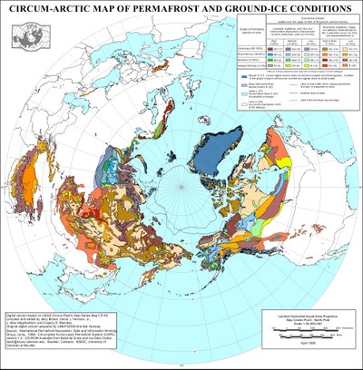
Permafrost is subsurface material, which shows temperatures below 0°C for a period longer than one year. Besides the large-scale distribution in subarctic and arctic lowlands, permafrost occurrences also exist on a smaller scale in mid-latitude high mountains like the Alps (Figure 1).
 |
Figure 1: Circumarctic map of permafrost and ground ice conditions
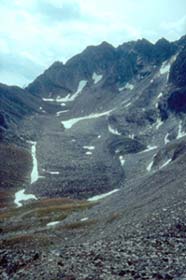
In the high mountains permafrost exists both in bedrock and in loose material (debris slopes, moraines, soil). Under permafrost conditions fissures and cracks in bedrock and cavities in loose material are normally filled with ice. With increasing ice content, the inner cohesion of loose material can be extremely reduced so that it becomes plastic by stress. Debris accumulations then start to move down-valley. Geomorphologic forms resulting from this movement are called "rock glaciers". They are the most striking signs for permafrost occurrences in the high mountains (cf. Figures 2&3).
 |
 |
Figures 2&3: Rock glaciers in the Jungtal, a tributary to the Mattertal (left) and Seetal, a tributary to the neighbouring Saastal (right). The fronts of both rock glaciers are situated in an altitude of about 2600 m a.s.l. Fig. 2 shows an example of a tongue-shaped type rock glacier, while Fig. 3 belongs to the lobate type.
The altitudinal belt of high mountain permafrost is situated below the glaciated areas. While continuous permafrost occurrences are restricted to the highest non-glaciated regions in the Alps, the belt of discontinuous or patchy mountain permafrost shows a larger vertical extent with a strong dependence on aspect. Individual permafrost bodies even occur as islands below the timberline in favoured locations (Figures 4&5).
 |
Figure 4: View into the catchment of the Riedgletscher (Matter Valley). The peaks are named (from left to right): Färichhorn (3290 m), Gr. Bigerhorn (3626 m), Nadelhorn (4327 m), Hohberghorn (4219 m) und Dürrenhorn (4035 m).
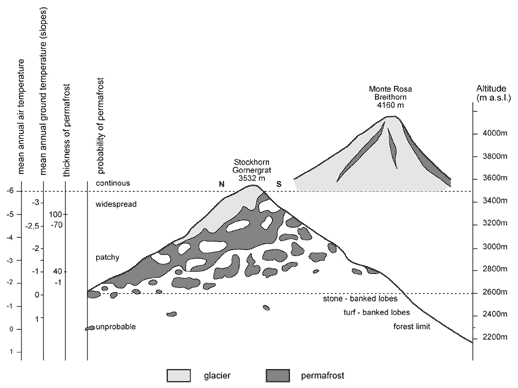
Permafrost thickness in the Alps is from a few up to more than 100 meters with temperatures ranging from a few tenths degrees up to several degrees centigrade below zero. The active layer thickness increases from a few decimeters in high altitudes to about five meters at the lowermost occurrences.
 |
Figure 5: Schematic section across the Gornergrat mountain crest, with probability and thickness of permafrost and expected mean annual air and ground temperatures for northerly slopes (KING 1990).
As a near surface phenomenon, permafrost is linked narrowly with the climatic conditions of a site. Whether a permafrost body can form and persist in the ground depends on the surface radiation balance, the mean annual air temperature and the winter snow depth and snow cover duration. Consequently, climate changes affect the permafrost distribution in the Alps.
A continued atmospheric temperature rise will cause an increase of the active layer thickness in the short term. Middle and long term consequences will be the melt-out of deep-lying permafrost bodies and finally a retreat of the permafrost belt in higher altitudes. It is assumed that the lower permafrost limit rose by approx. 150-250 m since the end of the Little Ice Age about a century ago. Results of the Swiss NFP 31 project forecast a rise by further 200-750 m while an atmospheric warming of 1-2°C for the next 50 years is expected.
The consequences of this rise are still hardly assessable in detail for mountain areas. The foundations of buildings as well as ropeway and lift installations are directly concerned. They are damaged by settlement and movements in the subsoil due to the melting out of ground ice.
Melting ice can also destabilize bedrock cliffs by changing the hydrological conditions in their joint system. Ice containing debris occurrences, moraines etc. lose their binding agent. As long as permafrost is present in the deeper subsoil, the thickened active layer can become unstable in summer due to intense snow melt or thunderstorms connected with heavy rainfall.
Altogether an increase of slope instabilities caused by permafrost retreat has to be expected resulting in rock falls, slumps or debris flows that often reach the valley bottom threatening settlement areas and infrastructures (Figures 6&7).
 |
 |
| Figure 6: Debris flow in the Täschbach (26.06.2001) | Figure 7: Damages in the village of Täsch |
An event of the youngest past probably triggered by melting permafrost is the catastrophic rockfall with a volume of 33 million cubic meters in the Val Pola (Valtellina) dated July 28th, 1987. In the rain rich summer 1987, numerous debris flows also appeared elsewhere. Half of the debris flows mapped in the Swiss Alps during summer 1987 originated in the periglacial belt with its numerous occurrences of permafrost.
